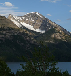
Photo: Looking southeast across Waterton Lake to Mount Boswell
Mount Boswell
- 2400 m (7,874ft)
- Naming History
Located in the Upper Waterton Lake Valley south of Hell-Roaring Creek; one km north of the U.S. border
Range: Wilson
Province: Alberta
Park: Waterton
Headwater: Oldman
Visible from Highway: 6
Named for: Boswell, (Dr. W.G. Boswell was the veterinarian for the International Boundary Commission.)
Dr. Boswell was the veterinarian on the International Boundary Survey and as such, was one of a team of scientists that completed an extensive amount of work in conjunction with the actual delineation of the border. Jack Street was a local resident who was killed in an avalanche and the mountain has been referred to as Mount Street. He was killed in an avalanche on Goat Haunt Mountain. I believe it was the west wall. His cabin was at the north end of the lake. He used to pan gold on the creek. He was apparently killed while hunting for goat on the walls. My grandfather (Frank Goble), got this information from Charlie Wise, a friend of Kootenai Brown and Jack Street who used to trap over in the Kishenenia. My father and I went up the valley trying to find the shovel and rifle that Kootenai has left as a grave marker. The cabin location was covered by thick alder, making it impossible to locate anything. Streets's trail on the north side of the creek (back side of Boswell) was still in pretty good shape (at least through the open). It disappeared in the trees. Apparently Jack and Kootenai used to run immigrants into the country by the head of the lakes. Unfortunately, like many Kootenai stories, not much other info is available. However there are some good stories of them having an uncomfortable cup of coffee with a law man who suspected what they were doing, but felt it wise not to press the situation. [Chris Goble] THE INTERNATIONAL BOUNDARY SURVEY (1872-1876) Much of the early exploration of Canada was undertaken by explorer-surveyors. Alexander Mackenzie, David Thompson, John Palliser, and Simon Fraser were explorers and adventurers of heroic stature. But the surveying of the new lands through which they travelled was a critical part of their work and each produced maps which were of great importance to the country's development. Others such as Dr. W.G. Boswell, and Donald Cameron were explorer-surveyors in a more limited sense, their work involving the more mundane task of determining the location and marking of the precise boundary which separates what was to become the Prairie Provinces from the United States. These explorer-surveyors, seldom far from their bulky surveying instruments, had their own challenges and rewards as new areas of Canada were made ready for orderly development. Undoubtedly they enjoyed the pleasure of exploring in some detail the spectacular scenery to be found in this corner of Alberta and of naming many of the features. Differences of opinion between Canada and the United States concerning the placement of the international boundary through the islands in the Strait of Georgia between the mainland and Vancouver Island had been settled cordially by an international boundary survey commission that existed from 1858 to 1862. This success led to the formation of a similar commission in 1870 that was given the task of marking the boundary from Lake of the Woods, Manitoba to the Continental Divide. Archibald Campbell, who had been the American chief commissioner for the 1858-1862 survey, was chosen to be the United States Commissioner of the survey. Prime Minister John A. Macdonald recommended a Scottish-born officer of the Royal Artillery, Capt. Donald Cameron to be the Campbell's Canadian counterpart. The natural history of the areas surveyed was to be studied as well and this aspect was put under the direction of 25 year old George Dawson, the son of the principal of McGill University. During the course of the survey Dawson gathered information that was eventually published as a 387 page "Report on the Geology and Resources of the Region in the Vicinity of the 49th parallel from the Lake of the Woods to the Rocky Mountains." This document established the scientific reputation of George Dawson. He became known as "Dr. George" and went on to become one of the most outstanding scientists Canada has ever produced, building the basis for much of the geological and botanical knowledge of western Canada. The two commissioners, Campbell and Cameron, first met in 1872 and the following year saw the beginning of the long trek westward. The contrast in policy towards the continent's native population was evident as the American surveyors were supported by 230 armed men, two companies of cavalry and a company of infantry, as a precaution against possible Indian hostility. On the other hand the British did not consider an armed escort necessary. In Cameron's opinion, the British flag was all the protection they required. The surveyors and their supply trains made for an impressive sight as they travelled across the dusty, desolate plains. The Americans used mules to haul their wagons; the British oxen to pull the legendary two-wheeled Red River Carts. Prairie fires and snowstorms hindered progress as summer ended. The surveyors had evolved into expert plainsmen, their lives a combination of adapting to challenging frontier conditions while at the same time remaining devoted to the scientific methods of their day. Through 1874 and 1875 the survey continued, extending the cairn marked boundary line across the three prairie steppes to the mountains and finally to the Continental Divide. By the time the final meeting of the Commissioners Campbell and Cameron was held in London in 1876, 388 survey monuments such as iron pillars, stone cairns, earth mounds, timber marks, and mounds of mixed earth and stone had been established along the 49th Parallel of latitude. The now visible evidence of an international border was quickly put to use by the North West Mounted Police. The bootlegging of liquor by Americans to the Canadian Indians could now be controlled. One of the first to make effective use of the newly marked border was Sitting Bull and his Sioux warriors who fled to safety in Canada after the massacre at Little Big Horn in Montana. At the conclusion of their work and after surveying the border across 1400 kilometres of prairie, the surveyors must have taken some satisfaction from naming some of the features in the mountainous portion of their assignment. Cameron Falls in Waterton Townsite and Cameron Lake, which straddles the international border, were named in honour of the Canadian Commissioner. Cameron had divided the functions of his commission into various categories. Dr. W.G. Boswell was in charge of the veterinary duties that must have been crucial to the smooth running of an "animal supported" surveying organization which covered thousands of kilometres. The slopes of Mount Boswell cross the 49th Parallel on the eastern side of Waterton Lake. Capt. Anderson, who was Cameron's chief astronomer, was honoured by having a mountain locally known as "Millionaires Peak" renamed Anderson Peak. Lt. R.E. Galwey was the Assistant Astronomer on the survey. Mount Galwey is located in the Blakiston Creek valley. The Americans honoured their commissioner, naming a peak just south of the border on the western side of Waterton Lake Mount Campbell. [A wonderful photo of the Canadian Survey Staff may be found in "50 Roadside Panoramas in the Canadian Rockies" by Dave Birrell]
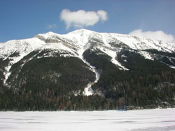
Photo: Looking east to Mount Boswell from Upper Waterton Lake (courtesy Edwin Knox)
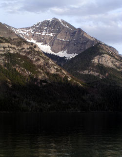
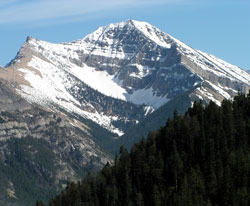
Looking southeast across Waterton Lake to Mount Boswell
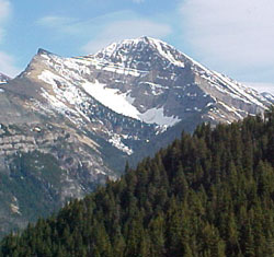
Looking south-southeast toMount Boswell from just above Waterton Townsite on the Cameron Lake Road
Looking south-southeast toMount Boswell from just above Waterton Townsite on the Cameron Lake Road