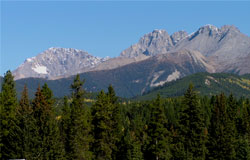
Photo: Looking north to Mount Verendrye (left), and White Tail Peaks
White Tail Peaks
- 2970 m (9,745ft)
- First Ascent
- Naming History
50.9861N -116.035W
Located west of the Vermilion River and northeast of the Kootenay River; 3.5 km southeast of Mount Verendrye and 3 km northwest of Mount Wardle
Range: Vermilion (BC)
Province: BC
Park: Kootenay
Headwater: Kootenay
Major Valley: Vermilion
Visible from Highway: 93S
Located west of the Vermilion River and northeast of the Kootenay River; 3.5 km southeast of Mount Verendrye and 3 km northwest of Mount Wardle
Range: Vermilion (BC)
Province: BC
Park: Kootenay
Headwater: Kootenay
Major Valley: Vermilion
Visible from Highway: 93S
Ascent Date: 1953
Ascent Party: B.A. Fraser, R.C. Hind, J.F. Tarrant
Ascent Party: B.A. Fraser, R.C. Hind, J.F. Tarrant
Year Named: 1961
Named by: Robin C. Hind
Named for: The mountain is at the head of White Tail Creek.
Named by: Robin C. Hind
Named for: The mountain is at the head of White Tail Creek.
The two peaks that make up this mountain are located at 673483 and 677486. They both have an elevation of approximately 9750'.
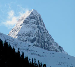
Photo: Looking southwest up Verendrye Creek to the northeast summit of White Tail Peaks from the Vermilion River Valley