
Photo: Looking northwest to Mount Vavasour (left) and Mount Warre from Burstall Pass (courtesy Rob Taerum)
Mount Warre
- 2743 m (9,000ft)
- Naming History
Located in the upper Spray River Valley south of White Man Creek at the head of Warre Creek
Province: Alberta
Park: Banff
Headwater: Bow
Named for: Warre, Lt. Sir Henry James (Lt. Warre crossed the Rockies with Lt. Mervin Vavasour in 1845-46 on a reconnaissance to determine what military action should be taken if there should be a war with the U.S. Warre was an artist, the first to visit the Rockies.
Lt. Warre and Mervin Vavasour crossed the Rockies with in 1845-46 and Mount Warre and Mount Vavasour stand together immediately east of White Man Pass, through which they crossed the Continental Divide. Lt. Henry James Warre of the 14th Regiment and Mervin Vavasour of the Royal Engineers were ordered by the Governor General to cross the Rockies disguised as private adventures and evaluate the mountain passes from a military point of view. Warre documented their journey in a journal that was later published as, "Sketches in North America and the Oregon Territory." He described the trip as follows, "Our passage over the magnificent range of the lofty mountains was not accomplished without much difficulty, and a fearful sacrifice of the noble animals that aided us in the transport. We left Edmonton with sixty horses; on our arrival at Fort Colville, on the Columbia River, we had only twenty-seven, and several of these so exhausted they could not have continued many more days. The steepness of the mountain passes, the want of proper nourishment, the fearful falls that some of the animals sustained, rolling in some instances many hundred feet into the foaming torrent beneath, combined to cause this great loss. The scenery was grand in the extreme; similar in form to the Alps of Switzerland, you felt that you were in the midst of desolation: no habitations, save those of the wild Indians were within hundreds of miles; but few civilized beings had ever even viewed this. Warre's completed a series of excellent sketches along the way, one of which clearly shows a portion of Mount Rundle and Cascade Mountain. These were the first "artist's impressions" ofthe Canadian Rockies. As for the military possibilities, Warre and Vavasour concluded that, "the idea of transporting troops...with their stores, etc. through such an extent of uncultivated country and over such impractable mountins woud appear to us quite infeasible."
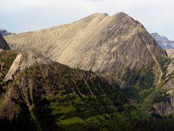
Photo: Looking northwest to Mount Warre from Burstall Pass (courtesy Rob Taerum)