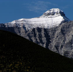
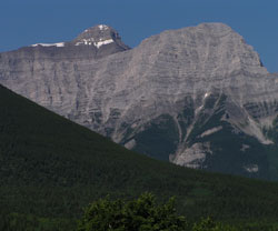
Photo: Looking west-southwest to Mount Bogart from Highway #40 (beyond the south ridge of Ribbon Peak)
Mount Bogart
- 3144 m (10,315ft)
- First Ascent
- Naming History
Located east of Spray Lakes Reservoir and west of the Ribbon Creek Valley
Province: Alberta
Park: Kananaskis
Headwater: Bow
Visible from Highway: 1, 40S
Ascent Party: Katie Gardiner
Ascent Guide: Walter Feuz
Named for: Dowling, Dr. Donald Bogart (Dr. Dowling was a geologist who worked in coal, petoleum and natural gas development.)
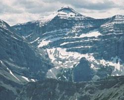
At 3144 metres, Mount Bogart is one of the most impressive mountains in the Kananaskis Valley. When viewed from the Kananaskis Valley below Kananaskis Village, the mountain lies 4.5 kilometres beyond Mount Kidd. It rises almost two hundred metres higher than Mount Kidd and the snow lingers longer on its summit than on the neighbouring peaks in the area. An excellent viewpoint is from near the junction of road to the Kananaskis Village and Highway #40. The Ribbon Creek Valley flows towards this viewpoint between the forested slopes. It then turns towards the southwest to its headwaters to the west of the south summit of Mount Kidd. The lower peak to the right of Mount Bogart (as seen from Highway #40) is unofficially referred to as Ribbon Peak and tends to hide Mount Bogart from some angles. Mount Bogart is connected by a long, high ridge, to Mount Sparrowhawk, the peak to the north. On August 12, 1858 Thomas Blakiston of the Palliser Expedition, ". . . left the main body of the exploring expedition at the site of Bow Fort. . ." and travelled to the southeast passing to the east of Moose Mountain. The following day he continued south, noting in his report, "as we travelled along through a partially wooded country, and receded from the near hills which obstructed the view, a sharp peak entirely covered with snow opened to us at about forty miles distance. The wind was from the westward, and to the east of the summit of the peak rested a mass of white cloud, which was very marked, for there were no other clouds to be seen, with the exception of a few light cirri overhead. This attending cloud gave the mountain the appearance of an active volcano and the effect against the clear sky was extremely beautiful. The phenomenon was caused by the aqueous vapour of the warm Pacific breeze being condensed by the coldness of the snow, and appearing as a cloud to the leeward of the peak. I took careful bearings of this mountain, to which I gave the name of 'The Pyramid'." It appears that Blakiston may have been describing Mount Bogart. It is often the case that Mount Bogart, being higher than its neighbours, is the only peak seen in the area that was being viewed by Blakiston that is snow-covered. Donaldson Bogart Dowling (1858-1925) was a geologist who joined the Geological Survey of Canada in 1885 and worked for it until his death. Like George Dawson, a director of the GSC and one of the first scientists to study the Rockies, he reported not only on the geology, but the geography, flora, fauna, and native history as he explored what was then, in a scientific sense, an unknown area. To work for the GSC in those early days required individuals such as Dowling and Dawson to be rugged outdoorsmen and explorers as well as outstanding scientists.
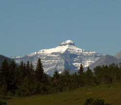
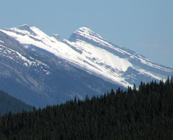
Looking southwest to Mount Bogart from the Trans-Canada Highway near the Morley Road
Looking east-northeast to Mount Bogart (courtesy Rob Taerum)
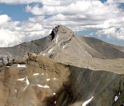
Photo: Looking east-northeast to Mount Bogart from Mount Buller (Bennett Wong)
Looking east-northeast to Mount Bogart (courtesy Rienk Lakeman)
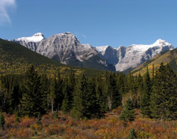
Looking southeast up the Spray Valley to Mount Bogart from the Trans-Canada Highway near Vermilion Lakes
Looking west-southwest to Ribbon Peak (Mount Bogart beyond at left) from Highway #40
Looking west-southwest to (l-r) Mount Bogart, Ribbon Peak, and Mount Sparrowhawk from Highway #40
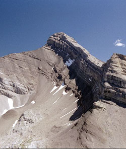
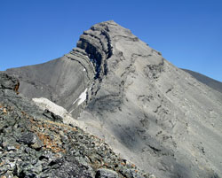
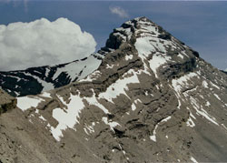
Looking southeast to the summit block of Mount Bogart (courtesy Bennett Wong)
Looking south to Mount Bogart from Mount Allan (courtesy Ron Hunter)