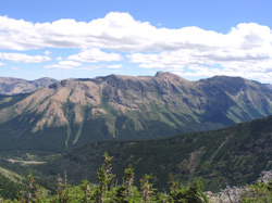
Photo: Looking southeast to Southfork Mountain on the northern end of Barnaby Ridge from St. Eloi Ridge (courtesy Linda Breton
Southfork Mountain
- 2330 m (7,645ft)
Located at the northwest end of Barnaby Ridge at the head of Barnaby Creek
Province: Alberta
Headwater: Oldman
Visible from Highway: 774
Southfork Mountain forms the northern end of Barnaby Ridge. The name of Southfork Mountain derives from the fact that the Castle River was originally referred to as the "South Fork" of the Oldman River and later as "Southfork River." Part I of the Interprovincial Boundary Survey (1917) reads as follows, "The term "North Fork" was appied by him (George Dawson) to distinguish this branch of "Old Man River" from the "South Fork" of the same stream, which heads on the east side of the watershed not very far north of South Kootenay Pass and joins the "North Fork" a few miles northwest of Pincher Station on the Canadian Pacific Railway. The name "South Fork Old Man River" was subsequently changed to "Southfork River" and again, quite recently, to Castle River. For the northern branch, the term "North Fork" has been dropped and it is now known as Oldman River."
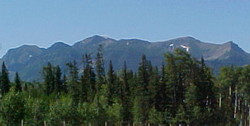
Photo: Barnaby Ridge from the north on Highway #774 near the confluence of the Castle and West Castle Rivers (Southfork Mountain is the two high points on the right side)