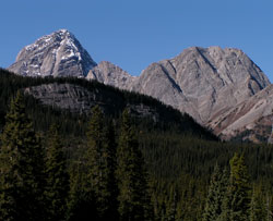
Photo: Pig's Tail (left) and Commonweath Peak from the Smith-Dorrien Road
Pig's Tail
- 2822 m (9,260ft)
- First Ascent
50.7867N -115.360W
Located north of Burstall Creek and south of Commonwealth Creek; between Mount Birdwood and Commomweath Peak; 600 metres east-northeast of Mount Birdwood
Range: Spray
Province: Alberta
Park: Kananaskis
Headwater: Bow
Visible from Highway: 742
Located north of Burstall Creek and south of Commonwealth Creek; between Mount Birdwood and Commomweath Peak; 600 metres east-northeast of Mount Birdwood
Range: Spray
Province: Alberta
Park: Kananaskis
Headwater: Bow
Visible from Highway: 742
Ascent Date: 1971
Ascent Party: Charlie Locke, L. Locke, J. Tanner
Ascent Party: Charlie Locke, L. Locke, J. Tanner