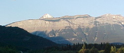
Photo: The Palisade (with The Pyramid beyond) from the northeast on Highway #16
The Palisade
- 2130 m (6,989ft)
- Naming History
52.9908N -118.129W
Located in the Athabasca River Valley, 4 km northwest of Pyramid Mountain
Province: Alberta
Park: Jasper
Headwater: Athabasca
Major Valley: Athabasca
Visible from Highway: 16, 93N
Located in the Athabasca River Valley, 4 km northwest of Pyramid Mountain
Province: Alberta
Park: Jasper
Headwater: Athabasca
Major Valley: Athabasca
Visible from Highway: 16, 93N
Year Named: 1924
Named for: The cliffs resemble a defensive fortification.
Named for: The cliffs resemble a defensive fortification.
The Palisade is a seven kilometre long ridge with steep cliffs of Devonian Palliser Formation limestones facing the Athabasca Valley. Early travellers noticed its resemblance to a defensive military position.
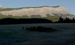
Photo: The Palisade from Highway #16, 3 km south of Snaring River
The Palisade from Highway #16, 3 km south of Snaring River
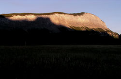
Looking northwest to The Palisade