Photo: Aiguille Peak from the Icefields Parkway at the north end of Lower Waterfowl Lake
Aiguille Peak
- 2999 m (9,840ft)
- First Ascent
- Naming History
Located in the Mistaya River and Blaeberry River Valleys above Cirque Lake; 0.3 km west of Mount Synge
Province: BC
Park: Banff
Headwater: Saskatchewan
Visible from Highway: 93N
Ascent Party: Mr. and Mrs. J.D. Mendenhall
Named by: Arthur Wheeler
Named for: Aiguille is the French word for needle and is used to refer to any pointed, alpine summit.
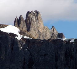
Small but distinctive mountains have a particular appeal and Aiguille Peak is one of those which can become a favourite as one travels along the Icefield Parkway in the Mistaya Valley. In order to accommodate the peak, the Divide makes a very abrupt jog to the southwest of Mount Synge and then back again. So even though Aiguille appears to the left of Mount Synge from the Silverhorn Creek Bridge, it is actually a few hundred metres farther along the border. The summit of the upper portion of the mountain can be seen rising sharply between Midway Peak and Mount Synge from this viewpoint. "Aiguille" is the French word for needle, and the term is used in a general sense for any sharp, alpine peak. Numerous peaks in the Alps use the word in their names. If you?re travelling north from the Silverhorn Creek Bridge it is interesting to watch Aiguille disappear behind Mount Synge and then, as you reach the northern end of Lower Waterfowl Lake, reappear dramatically but now between Mount Synge and Howse Peak. The mountain is most impressive from this viewpoint, with vertical cliffs and needle-like spires.
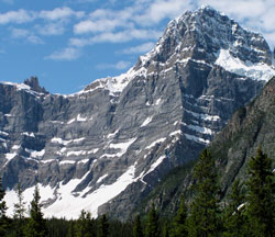
Photo: Aiguille Peak (left) and Howse Peak from the Icefields Parkway at the north end of Lower Waterfowl Lake